
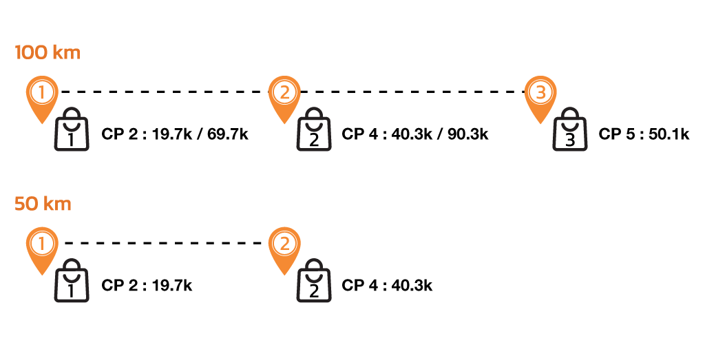
100 KM and 50 KM runners have the opportunity to prepare a maximum of 3 bags for 100 KM and 2 bags for 50 KM (1 bag per check point) to help support yourself along the race. Runner can pack energy fuels, energy drinks, fresh clothes, personal medications, etc. Each bag will be dropped off at the 5 specified check points on the course.
นักกีฬาระยะ 100 กม. และ 50 กม. ได้รับสิทธิ์ฝากถุงสัมภาระสํารองสูงสุดถึง 3 ใบ สำหรับระยะ 100 กม. และสูงสุดถึง 2 ใบ สำหรับระยะ 50 กม. เพื่อใช้ในจุดเช็คพอยท์ทั้ง 5 จุด (1 ใบต่อ 1 เช็คพอยท์) นักกีฬาสามารถนําสิ่งของที่ต้องการใช้ระหว่างการแข่งขัน ไม่ว่าจะเป็นอาหารเสริมให้พลังงาน เครื่องดื่มเกลือแร่ เสื้อผ้า หรือ ยาประจําตัวต่างๆ ซึ่งทางผู้จัดฯจะนําส่งถุงแต่ละใบไปที่จุดเช็คพอยท์แต่ละจุดตามที่ระบุ
The only available date and time to check-in the bags is on Friday, 17th January 2025 from 14:00 until 20:00 hr at the race venue during race kit collection. Bags that are checked-in after 20:00 hr will not be accepted. It is impossible to check-in bags on race day.
นักกีฬาต้องนําฝากถุงสัมภาระสํารองในวันศุกร์ที่ 17 มกราคม 2568 เวลา 14.00 น. – 20.00 น. เท่านั้น ณ บริเวณที่รับของที่ระลึก ที่ The Secret Towns Khao Yai โดยจะไม่มีการรับฝากถุงสัมภาระสํารองหลังจากเวลาที่ระบุดังกล่าว หรือในเช้าวันแข่งขัน ไม่ว่ากรณีใดๆ ทั้งสิ้น
Note: It is not mandatory for runner to use the bag drop service. The quantity of the bags depends on each runner, but the maximum is 3 bags for 100 KM and 2 bags for 50 KM (1 bag per check point). It is recommended using waterproof bags, marked with your name, bib number and check point number (number 2,4,5) that you want your bags to be dropped off. Please DO NOT put any valuable items in the bags, as we cannot guarantee security.
หมายเหตุ ไม่มีการบังคับฝากถุงสัมภาระทุกจุด จํานวนถุงสัมภาระขึ้นอยู่กับความต้องการของนักกีฬา แต่จะฝากได้ไม่เกิน 3 ใบ สำหรับระยะ 100 กม. และ 2 ใบ สำหรับระยะ 50 กม. (1 ใบ ต่อ 1 เช็คพอยท์) ถุงสัมภาระทุกใบควรกันน้ําได้ รวมทั้งเขียนชื่อ เบอร์วิ่ง และ จุดเช็คพอยท์ที่ต้องการฝาก (เช็คพอยท์เบอร์ 2,4 และ 5) กรุณาอย่าใส่ของมีค่าในกระเป๋าฝาก ผู้จัดฯไม่รับผิดชอบกรณีสูญหาย
After race day, runner will be able to pick up the bags from every check point on Sunday, 19th January 2025 from 09:00 – 17:00 hr at The Secret Towns Khao Yai.
Note : Bag Drop Service at Check Points is subject to change.
หลังจากวันแข่งขัน นักกีฬาสามารถมารับถุงสัมภาระสํารองที่ฝากไว้ที่เช็คพอยต์ต่างๆ ได้ในวันอาทิตย์ที่ 19 มกราคม 2568 ตั้งแต่เวลา 09:00 น. – 17.00 น. ที่ The Secret Towns Khao Yai
หมายเหตุ ขอสงวนสิทธิ์ในการเปลี่ยนแปลงจำนวนจุดเช็คพอยท์
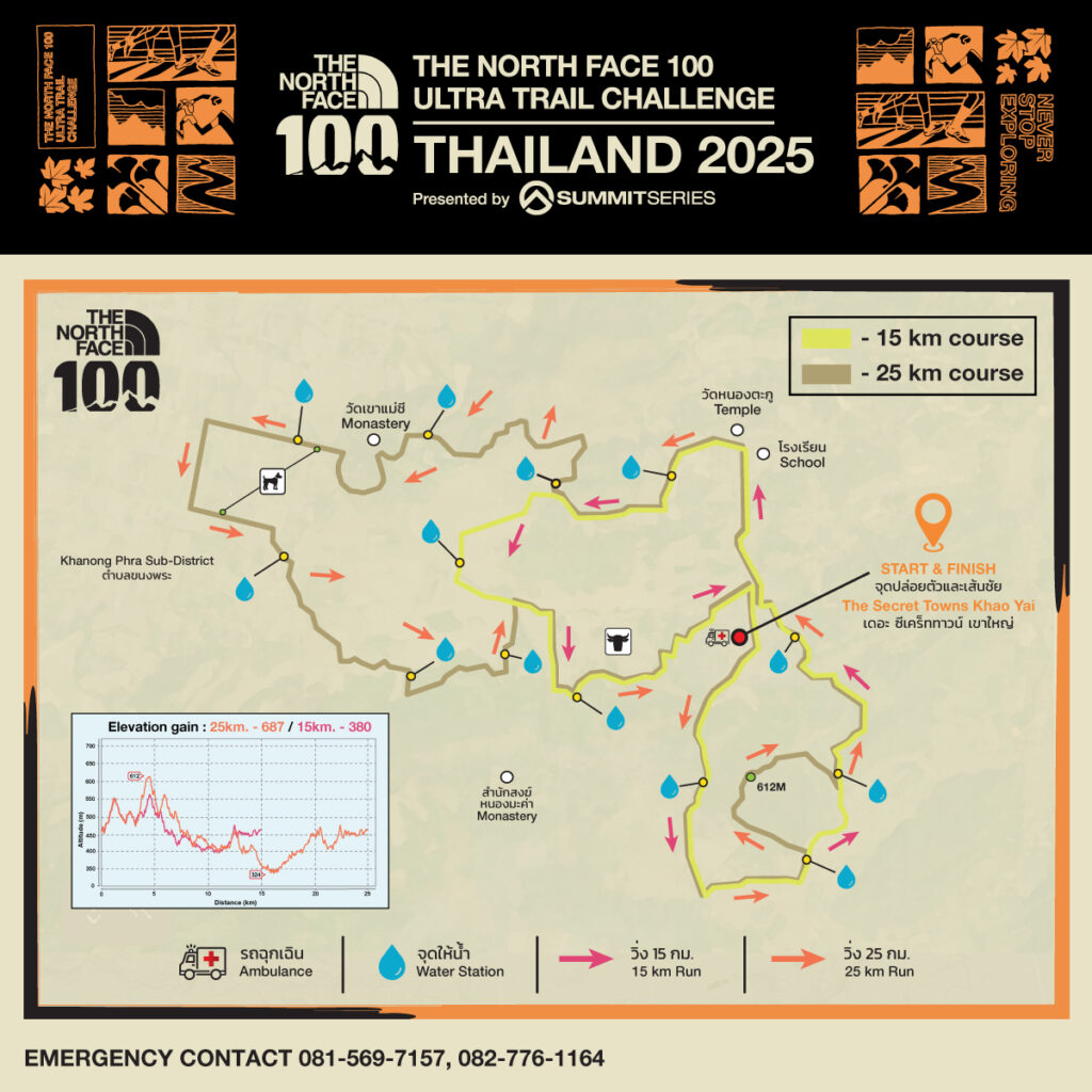
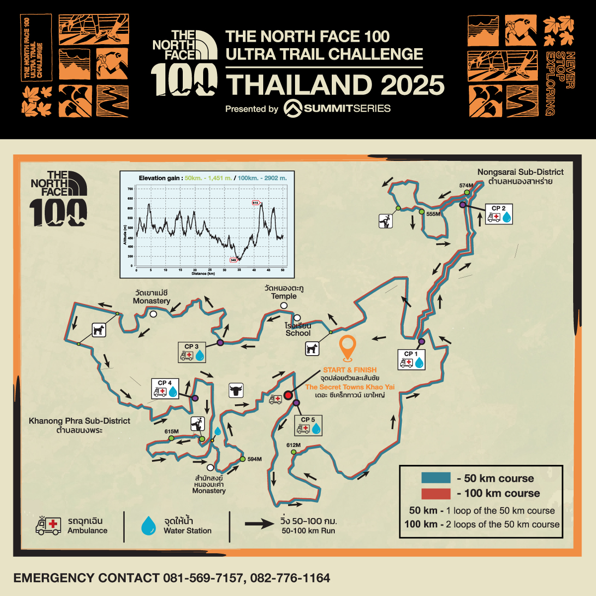
Course will be marked with distance marking every 5 KM, directional signs, and red-white flagging tape to indicate the way. At night, glow-in-the-dark sticks will be place along the race route. There will also be a ‘cross’ (x) sign on the route to indicate which route is the wrong way. Should you get lost or find yourself off the course, please track back to the last marker seen.
การบอกระยะทางจะมีติดตั้งประมาณทุกๆ 5 กม. รวมทั้งมีป้ายลูกศร และ แถบขาว-แดงบอกตลอดเส้นทาง ในเวลากลางคืนจะ มีการติดตั้งแท่งเรืองแสงเพื่อนําทาง นอกจากนั้นจะมีป้ายกากบาท (X) ตามทางแยกเพื่อบ่งบอกเส้นทางที่ไม่ใช่เส้นทางการแข่งขัน หากรู้สึกว่าตนเองออกนอกเส้นทาง โปรดย้อนกลับไปยังจุดสุดท้ายที่ท่านเห็นเครื่องหมายนําทาง

หมายเหตุ สัญลักษณ์นําทางจะติดตั้งก่อนการแข่งขัน อาจสูญหายหรือชํารุด